CAMP SAFETY UPDATE: Due to the ongoing fire activity, camp operations for the remainder of the 2026 summer have been suspended. All campers, staff, and volunteers are safe. Thank you for your continued prayers, trust, and support.
Big Muddy Airstrip Operations Overview
Pilots wishing to conduct flight operations at Big Muddy Airstrip (2OR1) must follow the steps below prior to being approved.
- Review Big Muddy Airstrip Policies
- If the minimum requirements are met as outlined, please complete the Big Muddy Pilot History-Liability Release Form and upload your current certificate of insurance by clicking here.
A Washington Family Ranch staff member will contact pilot, conduct a safety briefing, and approve pilot for flight operations at Big Muddy Airstrip (BMA).
- If minors are being transported via aircraft to/from BMA, the form Permission For Camper to Arrive or Leave Camp Via Airplane must be completed and returned to the Washington Family Ranch prior to flight.
A few things to note:
- Permission is required prior to each flight into BMA.
- With 2 days advance notice, we can make arrangements for someone to pick up pilot and passengers from hanger and transport them into the Washington Family Ranch.
- The liability release form needs to be updated every 2 years in order for pilot to retain “approved” status. Proof of insurance needs to be updated every year.
- Permission to conduct flight operations will be coordinated with camp schedules in order to minimize disturbance to guests.
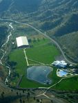
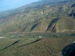
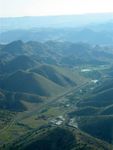
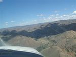
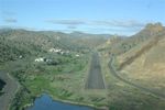
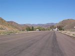
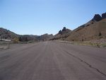
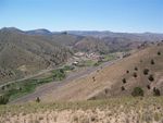
The runway's location creates additional challenges for landing and taking off. Please see photos below for approach and views of the surrounding hills.
Photos of a visiting DC-3
(click to enlarge photos)
Local Attractions
The Painted Hills are located 16.8 statute miles, southeast or 119 degrees (magnetic) of our airstrip. If you have the time and fuel, consider adding this to your waypoints (44D39.1603M North, 120D15.4762M West). It's a very unique deposit of volcanic ash that makes for some great photos when viewed in the early morning or evening hours.


